
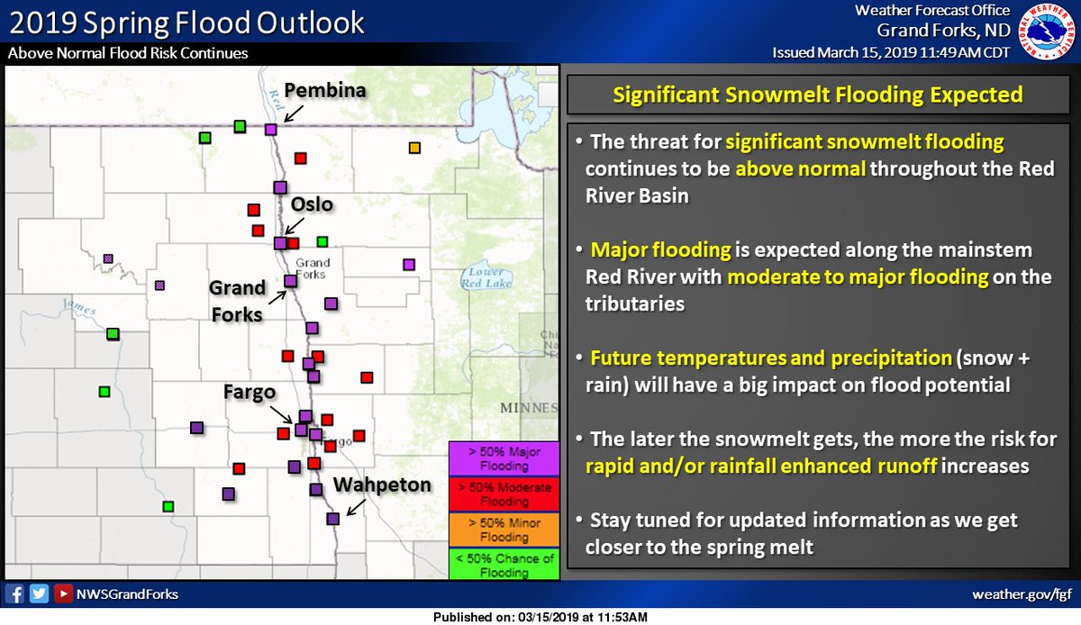
US flood forecasters upped their flood forecast numbers Friday after two major snowstorms in a week dumped up to 40 mm of precipitation on the Red River Valley south of the border.

The probability of major flooding went up along the Red River, with major to moderate flooding possible along its tributaries, said the US National Weather Service (NWS) in Grand Forks.
In previous weeks, flood forecasters were predicting more moderate flood levels.
Some areas, including Drayton, East Grand Forks, Halstad and Fargo have a small chance (five to 10 per cent) of exceeding the flooding seen in 1997, dubbed the “Flood of the Century,” according to the NWS.
However, it’s much more likely the flood will be a few feet below that level.
Still, that would make flood levels the worst the area has seen since 1997, said the NWS.
Global News weather anchor Mike Koncan was in Fargo, ND during the week and got stuck there for three days.
“Fargo, N.D., got its fare shake of Winter Storm Ulmer, as I saw it called,” he said.
“There was certainly more rain than snow and the winds were intense — over 90 km/h in Fargo and over 100 km/h in Aberdeen.”
“The total precipitable water from these storms adds up to roughly 40 mm — it is more moisture than the city will typically see during the entire month of March. The normal amount is around 33 mm.


The province of Manitoba has yet to issue a second flood forecast for southern Manitoba, with the last one being in late February.
However, they said they will be taking this week’s precipitation, which also saw major snowfalls in south eastern Manitoba due to the two storms, into account.
Water from the Red River Basin in North Dakota ends up in the Red River, which flows north into Manitoba. While the floodway will protect Winnipeg, flood forecasters and engineers have told Global News it’s likely the floodwaters will rise outside the city and likely result in the shutdown of Hwy 75.
- Life in the forest: How Stanley Park’s longest resident survived a changing landscape
- ‘Love at first sight’: Snow leopard at Toronto Zoo pregnant for 1st time
- Carbon rebate labelling in bank deposits fuelling confusion, minister says
- Buzz kill? Gen Z less interested in coffee than older Canadians, survey shows
Comments