Story highlights
2017 has produced 14 named storms -- 9 hurricanes, five of those Category 3 or more
There are nearly eight more weeks left in hurricane season, which ends November 30
As former Hurricane Nate drags its tropical depression winds and rain northeastward in the United States, another system is swirling in the eastern Atlantic, looking likely to become a tropical storm later Monday.
If the 2017 hurricane season – due to continue for nearly eight more weeks, until the end of November – feels particularly active, it’s because it has been.
CNN Meteorologist Jennifer Varian says the season has been obviously worse than others, ranking it the most active hurricane season since 2005.
The 2005 Atlantic hurricane season – the year of Katrina – blew away records with 28 named storms, of which 15 were hurricanes.
So far, 2017 has spawned 14 named storms, 9 of which were hurricanes and five of which turned into major hurricanes of Category 3 or more, Varian said.
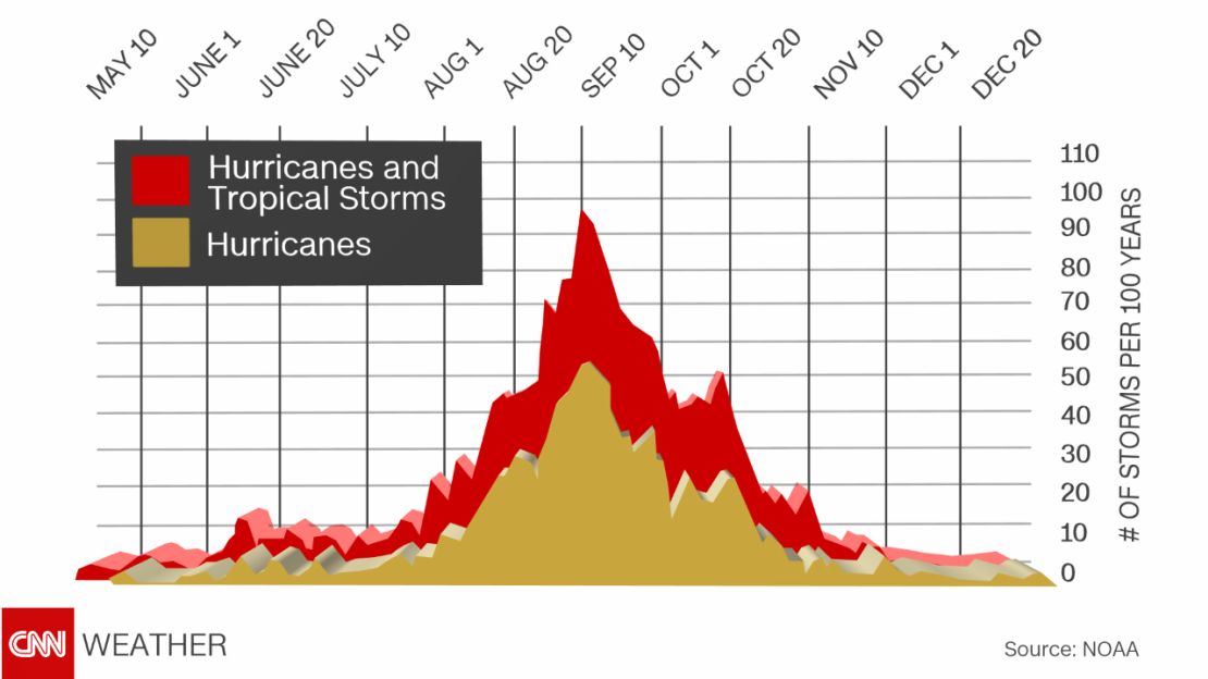
“The peak of the hurricane season is the first or second week of September, but it’s not over till the end of November. October is usually active and there could be a few more named storms.”
With nine consecutive named storms becoming hurricanes already, it would take just two more to break the record of 10 set in 1878 and matched in 1886 and 1893, she said. And there’s that system spinning in the far east Atlantic.
In its 5 a.m. ET update, the National Hurricane Center said the system had become a tropical depression with winds of 35 mph (55 km/h). The center said it was likely to strengthen and turn into a tropical storm – which requires winds of 39 mph – later Monday. So Ophelia – the next name on the center’s list – could attach itself to a storm sooner rather than later.
“If Ophelia and Philippe become hurricanes then we will break the record with 11 consecutive,” Varian said. “Sea surface temperatures have been in the mid to upper 80s (degrees Fahrenheit) consistently through the season – hurricanes love hot water.”
Warm ocean water is also one of the key atmospheric ingredients that allows storms gain strength fast.
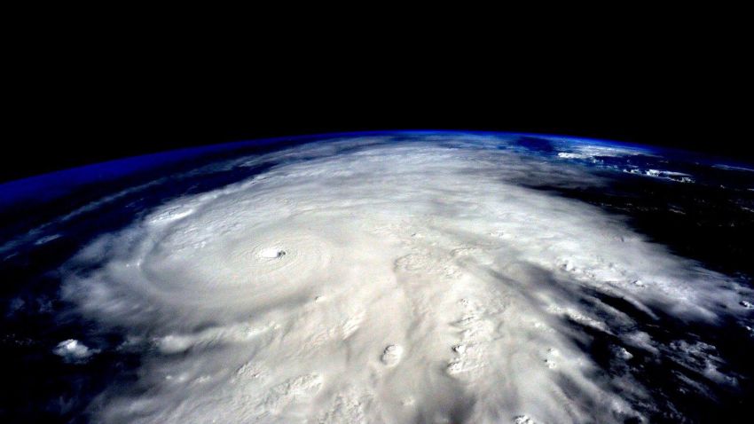
Harvey, Irma, Jose, and Maria went through a process of “rapid intensification,” meaning their maximum sustained winds increased at least 35 mph in 24 hours or less. That’s a jump of about two categories on the Saffir-Simpson scale, which grades hurricane strength from 1 to 5.

“Harvey blew-up in 12 hours, going from Category 1 to Category 3,” Varian said.
Lt. Gen. Russel Honoré led Task Force Katrina in the aftermath of the hurricane that struck the Gulf Coast in 2005. But, in an opinion article for CNN, he wrote that hurricanes Harvey, Irma and Maria were eye-opening to him

“I witnessed first-hand the flooding in Houston, the ravaged landscapes in Florida, and the devastation in Puerto Rico,” Honoré wrote.
“I’ve never seen such widespread damage and so many Americans suffering from direct hits, and these hurricanes really hit home the need to have a coordinated plan to deal with the three phases of any disaster: Preparation, Response, and Recovery,” he said.
Harvey made US landfall in late August as a Category 4 hurricane. Six days of rain caused extreme flooding in Texas and Louisiana and at least 57 people died. Estimates put eventual total losses at as much as $75 billion.

Soon after Harvey, deadly Hurricane Irma slammed the Caribbean before taking aim at Florida. Maria later followed a similar path, hitting already devastated areas of the Leeward Islands and causing massive damage in Puerto Rico.

What next for Nate?
The National Hurricane Center downgraded Nate to a tropical depression late Sunday morning. It issued its last advisory on the storm at 11 p.m. ET Sunday, when it said the weather system was about 70 miles (115 kilometers) east-northeast of Nashville, Tennessee.
“Nate is expected to continue tracking northeastward, moving into eastern portions of the Ohio valley states by Monday morning and into the northeast Monday evening as a post-tropical cyclone,” the center said.

Flash flood watches and warnings and high wind warnings and advisories are in place across the southern and central Appalachians, it said, with area specific information being issued by local National Weather Service offices.
The National Weather Service said Sunday that the greatest threat of flash flooding Monday was in northern Georgia through western North Carolina. Additional showers and thunderstorms could be expected across the Tennessee Valley, Southeast and lower Mississippi Valley on Tuesday with heavy rainfall in the middle Mississippi Valley by Tuesday evening.
Varian said while Nate had faded, the storm was still making an impact.
“What’s left is rain with tornadoes possible from the rain bands. For the next 48 hours we’re looking at widespread pockets of upwards of four inches in parts of Tennessee, North Carolina and Virginia – the central East.”
The trail behind
Although Nate’s threat has reduced and its impact on the US has been less than feared, the season’s most recent hurricane still leaves a trail of destruction behind it.
Nate made two US landfalls, the first late Saturday near the mouth of the Mississippi River in southeast Louisiana, with winds of 85 mph and the second near Biloxi Mississipi as a Category 1 hurricane.

Nate’s storm surge – a rise in water level as it approached the shore – caused flooding along the Gulf Coast and the storm knocked out power to 67,000 homes, most of them In Alabama.
But before taking aim at the US, Nate carved a path of devastation in Central America.
At least 28 people were killed Thursday in Costa Rica, Nicaragua and Honduras. Hundreds were rescued from floodwaters and mudslides. Many lost power and running water.
CNN’s Brandon Miller and Madison Park contributed to this report.