Weather
NJ Weather: Winter Storm Watch In 10 NJ Counties
New details have been released on two NJ snowstorms, one of which could produce prolonged power outages.


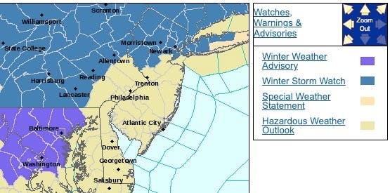
A winer storm watch has been issued in 10 New Jersey counties as new details have emerged on two snowstorms, one of which could trap the state in ice and create a mess for commuters and travelers begnning Friday (see road closures below).
The snow on has impacged school schedules. Read more: New Jersey School Closings/Delayed Opening List For 1/18/19
The National Weather Service has issued a winter storm watch for the Saturday and Sunday storm. Heavy mixed precipitation is possible after 12 noon on Saturday with total snow accumulations of at least 5 to 8 inches, and ice accumulations of up to one 10th of an inch are possible.
Find out what's happening in Hopatcong-Spartawith free, real-time updates from Patch.
The winter storm watch was issued for Sussex, Passaic, Bergen, Essex, Union, Hudson, Morris, Somerset, Warren and Hunterdon counties. The wind and ice from this storm could create prolonged power outages as well, forecasters say.
Here are the alerts:
Find out what's happening in Hopatcong-Spartawith free, real-time updates from Patch.
Travel could be very difficult at any point during the storm. Rapidly falling temperatures Sunday afternoon into the evening could cause any standing water to quickly freeze over. Strong wind gusts Sunday afternoon into the night could bring down tree limbs and power lines, according to the NWS.
As the storms approach, Gov. Phil Murphy also sought to reassure residents who are still fuming about the state's lackluster responses to storms this winter, saying: "We gotta do better."
"We're concerned," Murphy said of the two storms, the first of which is supposed to come Thursday evening and extend into Friday morning. "We're much more concerned about the potential sytem coming through on Saturday into Sunday."
-1547735372-2778.jpg)
Regarding the weekend winter storm event, I see a lot of people discussing snow amounts (as usual) and then also mentioning (sometimes) the icing potential for over 0.5" icing. Given the expected winds, we are looking at potential for Level 3 or 4 on this icing index. pic.twitter.com/xh3BKgCcVi
— Gary Szatkowski (@GarySzatkowski) January 17, 2019
Here are the road closures for the Friday snow:
- Ben Franklin Bridge: The North-Side Pedestrian Walkway will remain closed. Signs alerting the pedestrians of this temporary closure have been posted.
- Garden State Parkway: Speed restriction on the Garden State Parkway in both directions from South of Exit 109 - CR 520 in Middletown Twp to South of Exit 124 - Main St in Sayreville; 45 miles per hour due to salting operations.
- New Jersey Turnpike - Hudson County Extension: Speed restriction on the New Jersey Turnpike - Hudson County Extension in both directions from Interchange 14 - I-78 in Newark to Jersey Ave/Holland Tunnel in Jersey City; 45 miles per hour due to salting operations.
- New Jersey Turnpike: Speed restriction on the New Jersey Turnpike in both directions from Delaware Memorial Bridge in Pennsville Twp to George Washington Bridge in Fort Lee; 45 miles per hour due to salting operations.
- Garden State Parkway: Speed restriction on the Garden State Parkway in both directions from North of Exit 142 - I-78 in Hillside Twp to New York State Line in Montvale; 45 miles per hour due to Salting operations.
- New Jersey Turnpike - Pennsylvania Ext: Speed restriction on the New Jersey Turnpike - Pennsylvania Ext. in both directions from Delaware River Bridge in Burlington Twp to New Jersey Turnpike North in Mansfield Twp 45 miles per hour due to Salting operations.
- New Jersey Turnpike: Accident on the New Jersey Turnpike outer roadway southbound North of Interchange 14 - I-78/US 1&9 in Newark. Left and center lanes blocked.
- US 202: Utility Pole Down on US 202 southbound north of Town Center Rd in Bridgewater Twp. All lanes closed and detoured northbound left lane closed
- NJ 35: Utility Pole Down on NJ 35 southbound between CR 689/Lawrence Pkwy in Old Bridge Twp and north of County Rd in Aberdeen Twp. Right lane and shoulder closed for repairs.
Here is what's expected to happen this weekend:
Northwestern New Jersey is supposed to get the brunt of the Thursday system, with 3 to 4 inches of snow possible, said Joe Miketta, a National Weather Service meterologist. The rest of the state will likely get no more than an inch.
Miketta, however, broke down the possible snow totals for the Saturday and Sunday storm: 6 or more inches for North Jersey (north of I-78); 1-3 inches for Central Jersey (north of I-195) and about an inch for South Jersey.
Add to that, however, at least an inch of rain that could mix with the storm once is really starts to hit mid-Saturday afternoon – plus a flash-freeze late Sunday where temperatures could sink into the single digits. Then you have a commuting nightmare potentially on Monday morning, which is Martin Luther King Day.
Much of the rain will mix with the snow on Sunday morning, Miketta said.
"We're looking a fairly potent storm," said Miketta.-1547735639-5245.jpg)
-1547735539-4698.jpg)
Here are the estimates for the Thursday-Friday storm:
-1547735786-7996.jpg)
-1547737438-7286.jpg)
Murphy promised that the state was preparing the roads and taking care of commuting problems before they happen – unlike the November nor'easter that left thousands in an ice-and-snow commuting mess.
"I won't be bashful communicating with folks if I think we're going to get whalloped," he said.
Murphy's remarks on the storm are at 31:25:
- Thursday night: Snow likely, mainly between 11pm and 5am. Cloudy, with a low around 28. Light northeast wind. Chance of precipitation is 70%. New snow accumulation of less than one inch possible.
- Friday: A chance of snow before 7am. Cloudy, then gradually becoming mostly sunny, with a high near 42. Calm wind becoming west around 6 mph in the afternoon. Chance of precipitation is 30%. New snow accumulation of less than a half inch possible.
- Frida night: Partly cloudy, with a low around 28. West wind around 6 mph becoming north after midnight.
- Saturday: A chance of snow showers between 8am and 1pm, then rain and snow showers likely. Partly sunny, with a high near 35. North wind 5 to 10 mph becoming east in the afternoon. Chance of precipitation is 60%. New snow accumulation of less than a half inch possible.
- Saturday night: Rain and snow, becoming all rain after 10pm. Low around 34. Chance of precipitation is 90%. New precipitation amounts between 1 and 2 inches, or more, possible.
- Sunday: Rain before 2pm, then rain and snow between 2pm and 3pm, then snow after 3pm. High near 41. Chance of precipitation is 90%.
- Sunday night: Mostly cloudy, with a low around 10. Blustery.
Shutterstock and Tom Davis photos
Get more local news delivered straight to your inbox. Sign up for free Patch newsletters and alerts.