Talk to most mountaineers, trail runners, or mountain bikers, and they’ll tell you that hiking is the weak sibling of adventurous outdoor sports. A little too slow, a little too granola, not enough adrenaline.
But some of the most dangerous adventures in the world involve simply putting one foot in front of the other. Exposure, wild animals, guerrilla fighters, heat—just some of the variables that can turn a walk through the mountains into a flirt with death. And while many people complete these routes unscathed, they’re dangerous enough that a few mistakes can leave you seriously injured—or dead.
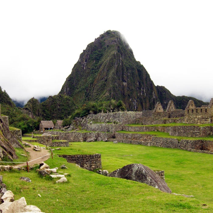
Huayna Picchu, Peru
Clouds and mist make the journey more difficult, and in some sections hikers must cling to old steel cables. Going up is the easy part. Coming down the steep slope often paralyzes travelers with fear. But it’s worth the pain—the view from Huayna Picchu on a sunny day is the best bird’s-eye view of Machu Picchu below. (MrHicks46/Flickr)
The Inca Trail to Machu Picchu can be a tough trek, and it takes a few casualties each year. But the real danger begins when you follow the trail past the mythical city and up Huayna Picchu, aka the “Hike of Death.” The old Inca staircase is carved out of granite and climbs about 1,000 feet in less than a mile. Plus, the route is full of rotting, crumbling rock, slippery stones, and exposed corners. Many people tackle the route totally unprepared—we’re talking flip-flops and no water.
Clouds and mist make the journey more difficult, and in some sections hikers must cling to old steel cables. Going up is the easy part. Coming down the steep slope often paralyzes travelers with fear. But it’s worth the pain—the view from Huayna Picchu on a sunny day is the best bird’s-eye view of Machu Picchu below.
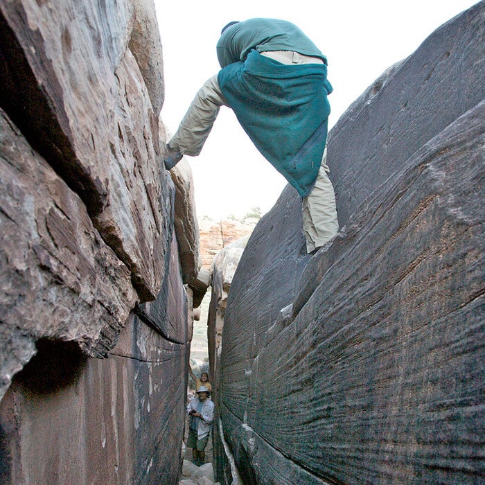
The Maze, Utah
The sheer danger of the place—which rangers emphasize to any visitors, insisting on detailed itineraries and good communication—has kept fatalities in the area to zero, though there was a double suicide in the summer of 2013. Deaths and accidents in the rest of Canyonlands, however, are a regular occurrence and show just how deadly the Maze would be—if anyone could get there. (Indigoprime/Flickr)
The most remote section of Canyonlands National Park receives about 2,000 visitors per year, and not because it isn’t worth visiting. The red rock labyrinth known as the Maze is difficult to reach, almost impossible to navigate, and full of dead-end gullies. It always presents the danger of rockfalls (think James Franco in 127 Hours) or deadly flash floods.
The sheer danger of the place—which rangers emphasize to any visitors, insisting on detailed itineraries and good communication—has kept fatalities in the area to zero, though there was a double suicide in the summer of 2013. Deaths and accidents in the rest of Canyonlands, however, are a regular occurrence and show just how deadly the Maze would be—if anyone could get there.
Mount Hua Shan, China
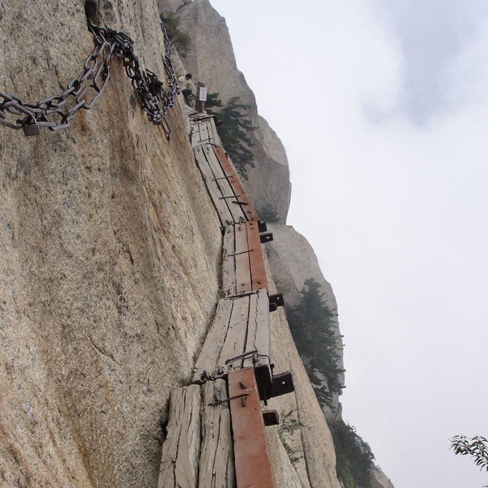
Trekkers need to hook into an iron chain paralleling the boards, which hover thousands of feet above the ground. Even getting to the trail is difficult and includes a climb up a vertical rebar staircase. At one point, the planks disappear entirely and hikers must use small divots carved into the rock. There are no official death statistics, but the rumor is that 100 people per year die on Hua Shan. Multiply that over centuries and it may be the deadliest peak in the world. (Ondrej Zvacek)
Pilgrims have climbed to the temples on the five spires of Mount Hua Shan for centuries. Almost all of the climbs are treacherous, with nearly vertical stairways and few handholds. However, the plank trail to the South Mountain is a different story. Called the most dangerous hike in the world, it consists of wooden platforms bolted onto the mountainside.
Trekkers need to hook into an iron chain paralleling the boards, which hover thousands of feet above the ground. Even getting to the trail is difficult and includes a climb up a vertical rebar staircase. At one point, the planks disappear entirely and hikers must use small divots carved into the rock. There are no official death statistics, but the rumor is that 100 people per year die on Hua Shan. Multiply that over centuries and it may be the deadliest peak in the world.
Kokoda Track, Papua New Guinea

In 2009, 13 people died in a plane crash en route to the trailhead, and four more hikers died on the trail, which takes up to 11 days to complete. They faced malaria, extreme heat, frigid nights, and daily bone-soaking afternoon rains. The route itself has been called a StairMaster in a steam room, with ankle-deep clay muck, slippery roots, and portions that become waterfalls. As you might expect, the death toll and the harsh conditions started to deter trekkers.
Since the ill-fated 2009 season, the governments of Australia and Papua New Guinea have spent millions of dollars bringing more modern facilities to the trail. You still have to watch out for all the dangers listed above, but the wild route is changing rapidly. (Luke Brindley/Wikimedia)
The Kokoda Track has seen plenty of death in its time. In 1942, it was the scene of intense fighting between the Japanese and Australians. The route lay almost dormant until the past decade, when adventurous trekkers discovered the 60-mile slog connecting the outskirts of Port Moresby to the village of Kokoda.
In 2009, 13 people died in a plane crash en route to the trailhead, and four more hikers died on the trail, which takes up to 11 days to complete. They faced malaria, extreme heat, frigid nights, and daily bone-soaking afternoon rains. The route itself has been called a StairMaster in a steam room, with ankle-deep clay muck, slippery roots, and portions that become waterfalls. As you might expect, the death toll and the harsh conditions started to deter trekkers.
Since the ill-fated 2009 season, the governments of Australia and Papua New Guinea have spent millions of dollars bringing more modern facilities to the trail. You still have to watch out for all the dangers listed above, but the wild route is changing rapidly.
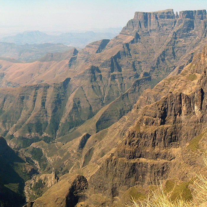
Drakensberg Traverse, South Africa
The most daunting part may be the beginning. Two rickety chain ladders take trekkers to the ridge, where animal tracks, herding trails, and rock scrambles are cobbled together to make up the trail. But the rewards are worth it, including a stop at the Amphitheater, a rock cliff that is three times larger in area than El Capitan. (PhilippN)
The stat that is often repeated about the Drakensberg Traverse is that before 1985, 55 people lost their lives here. After that, we guess, officials got tired of counting, but deaths are reported almost every year on the 40-mile trek through Natal National Park that crosses some of the most exposed—and beautiful—alpine terrain in the world.
The most daunting part may be the beginning. Two rickety chain ladders take trekkers to the ridge, where animal tracks, herding trails, and rock scrambles are cobbled together to make up the trail. But the rewards are worth it, including a stop at the Amphitheater, a rock cliff that is three times larger in area than El Capitan.
Cascade Saddle, New Zealand
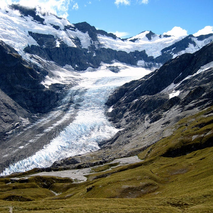
If you want all those Lord of the Rings vistas, you have to travel to Mt. Aspiring National Park on New Zealand’s South Island. But you might want to skip the route to the Cascade Saddle, an 11-mile, two-day trip through beech forest and alpine meadows. Despite the views, in the past few years at least 12 people have lost their lives in the saddle, mainly from falls while descending when the rock was wet and slippery. A German trekker fell to his death in July 2013, prompting the local coroner to demand that officials either close the path or reengineer it to make it safer.
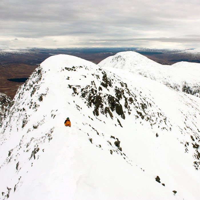
Aonach Eagach Ridge, Scotland
That's where most of the problems begin. Ridge walkers try to leave the ridge before reaching Sgorr nam Fiannaidh peak and the easy way down. Several accidents occur on the ridge every year, and there were two deaths in 2009. If you have a head for heights, you should be just fine dealing with the exposure—as long as you don't get stuck behind a group of less-able hikers. (Nick Bramhall/Flickr)
Aonach Eagach is one of Scotland's most iconic Highland scrambles. The four-mile route follows Glen Coe Valley, crosses two Munros (mountains), and offers some of the best views in the country. It also offers a knife-edge trail with steep scree and grassy slopes on either side, sections of technical scrambling, and no shortcuts off the ridge if the weather turns bad (which it's apt to do).
That's where most of the problems begin. Ridge walkers try to leave the ridge before reaching Sgorr nam Fiannaidh peak and the easy way down. Several accidents occur on the ridge every year, and there were two deaths in 2009. If you have a head for heights, you should be just fine dealing with the exposure—as long as you don't get stuck behind a group of less-able hikers.
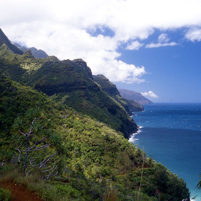
Kalalau, Hawaii
The trail has taken several lives and caused countless accidents, but the narrow path isn’t the biggest danger. More than 100 people have met their end while swimming on the trail’s remote beaches, and the transient community living on the shore can be rough. Two years ago, a drug addict threw a Japanese hiker off a cliff, setting off a four-month manhunt. (Jeff Kubina/Flickr)
The Kalalau Trail along the Na Pali Coast is Hawaii at its best—isolated jungle, steep volcanic slopes, and a pristine undeveloped beach at the end. But the 22-mile round-trip hike through paradise can turn sour quickly. The path’s three major stream crossings can swell rapidly during a rain, and falling rock, especially around waterfalls, is always a concern. Crawler’s Ledge, three-quarters of the way through the trek, can turn into a dicey walk along its sheer ledge during the rain.
The trail has taken several lives and caused countless accidents, but the narrow path isn’t the biggest danger. More than 100 people have met their end while swimming on the trail’s remote beaches, and the transient community living on the shore can be rough. Two years ago, a drug addict threw a Japanese hiker off a cliff, setting off a four-month manhunt.
El Caminito del Rey, Spain
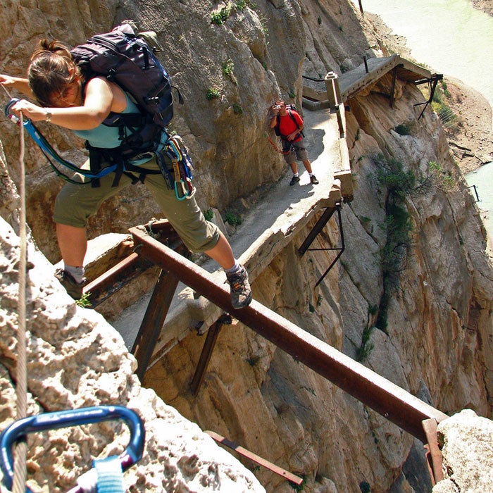
In the El Chorro Gorge in Spain’s Malaga province, the Caminito del Rey (Little King’s Path) hangs 100 feet up on sheer cliffs. The two-mile concrete and steel path was built more than 100 years ago to serve workers on a local hydroelectric plant, but over time it has become a destination for adventure seekers, especially as sections of the pathway have crumbled. Officially closed to the public, hikers still play Fear Factor on the route, which requires spidering over 10-foot sections of missing trail. Even if the state finishes a reconstruction of the path, the Caminito will still stay on the list of top vertigo-inducing trails.
Maroon Bells South Ridge, Colorado
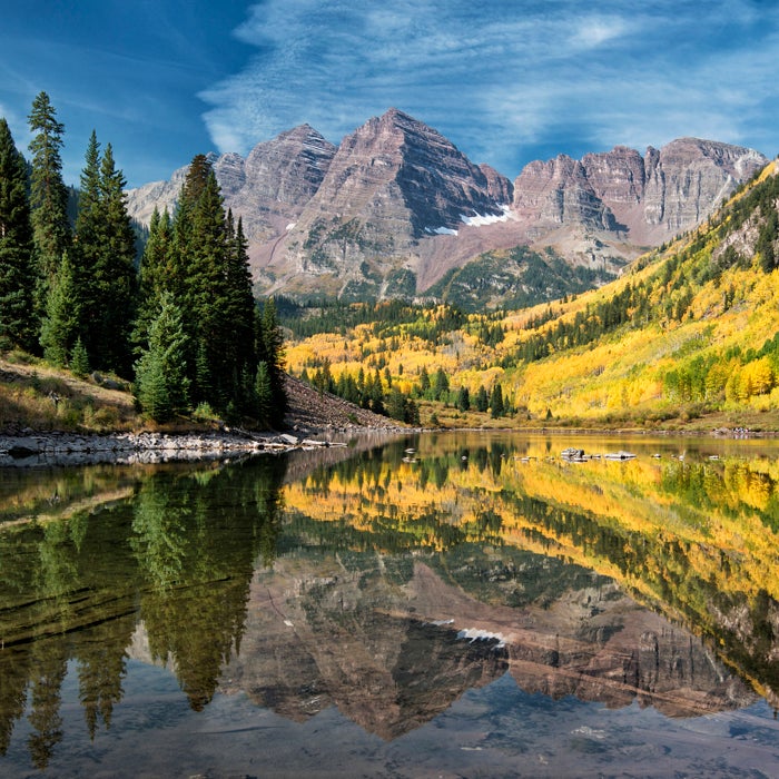
The trail is relatively easy until you get above 11,000 feet on its east slope. From there, the climb gets rougher the higher you get. The Maroon Bells got their deadly reputation after eight people died in five separate incidents, earning them the nickname “The Deadly Bells.” A U.S. Forest Service sign on the trail sums it up: “The beautiful Maroon Bells … have claimed many lives in the past few years. They are not extreme technical climbs, but they are unbelievably deceptive. The rock is down sloping, rotten, loose, and unstable. It kills without warning. The snowfields are treacherous, poorly consolidated, and no place for a novice climber. … Expert climbers who did not know the proper routes have died on these peaks.” (mark byzewski/Flickr)
The Maroon Bells boast some of the most scenic hiking in the country, and many people complete the route safely every year—but it’s not to be taken for granted. The 12-mile round-trip hike to the summit of the South Ridge is fraught with loose rock fields, steep paths, gullies, and plenty of places to get lost. Oh yeah, and there’s the mercurial weather.
The trail is relatively easy until you get above 11,000 feet on its east slope. From there, the climb gets rougher the higher you get. The Maroon Bells got their deadly reputation after eight people died in five separate incidents, earning them the nickname “The Deadly Bells.” A U.S. Forest Service sign on the trail sums it up: “The beautiful Maroon Bells … have claimed many lives in the past few years. They are not extreme technical climbs, but they are unbelievably deceptive. The rock is down sloping, rotten, loose, and unstable. It kills without warning. The snowfields are treacherous, poorly consolidated, and no place for a novice climber. … Expert climbers who did not know the proper routes have died on these peaks.”
Mist Trail, California
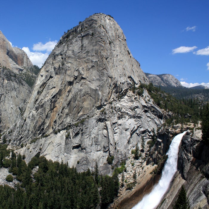
Steel cables assist climbers on the last 400 feet of the ascent, but this final assault still poses a challenge. You need to be in excellent shape to make it up, and rainfall makes the cables extremely slippery. If there's any threat of lightning, the cables' exposed position becomes extremely dangerous. Five people have died on Half Dome in the past nine years alone, and most of those accidents happened when the rock was wet. (Ray Bouknight/Flickr)
The 14.5-mile Mist Trail is one of the most popular routes up Yosemite National Park's Half Dome. Though up to 3,000 hikers escape the trail unscathed every day in the summer, there are a few tricky spots that could leave you seriously injured if you're unprepared. According to a Yosemite hiking website, more than 60 people have died on Half Dome and the trail leading up to it.
Steel cables assist climbers on the last 400 feet of the ascent, but this final assault still poses a challenge. You need to be in excellent shape to make it up, and rainfall makes the cables extremely slippery. If there's any threat of lightning, the cables' exposed position becomes extremely dangerous. Five people have died on Half Dome in the past nine years alone, and most of those accidents happened when the rock was wet.
Longs Peak, Colorado
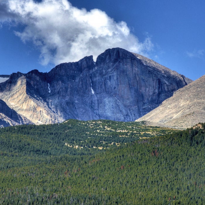
The Longs Peak trail is tame until you reach a section known as the Keyhole. From there, hikers must scramble along narrow ledges, following painted bull's-eyes to stay on course. It's not technical climbing, but it's easy for hikers to get in over their heads.
One of the more famous people to die on Longs Peak was mountaineer Agnes Vaille. After she and a companion successfully summited, Vaille fell 150 feet down a rock field. Exhausted, she told her friend that she would take a short nap before resuming the hike, but she froze to death by the time rescuers found her. Agnes Vaille Shelter, a small cabin on the trail, serves as a memorial to her. (John Fowler/Flickr)
One of Colorado's most popular peaks is also one of the deadliest, thanks to high exposure, rock slides, frequent lightning strikes, and narrow ledges. An average of one person a year dies on the mountain, and with a difficulty rating of Class 3, it's one of the most challenging standard routes up a 14er in the state.
The Longs Peak trail is tame until you reach a section known as the Keyhole. From there, hikers must scramble along narrow ledges, following painted bull's-eyes to stay on course. It's not technical climbing, but it's easy for hikers to get in over their heads.
One of the more famous people to die on Longs Peak was mountaineer Agnes Vaille. After she and a companion successfully summited, Vaille fell 150 feet down a rock field. Exhausted, she told her friend that she would take a short nap before resuming the hike, but she froze to death by the time rescuers found her. Agnes Vaille Shelter, a small cabin on the trail, serves as a memorial to her.
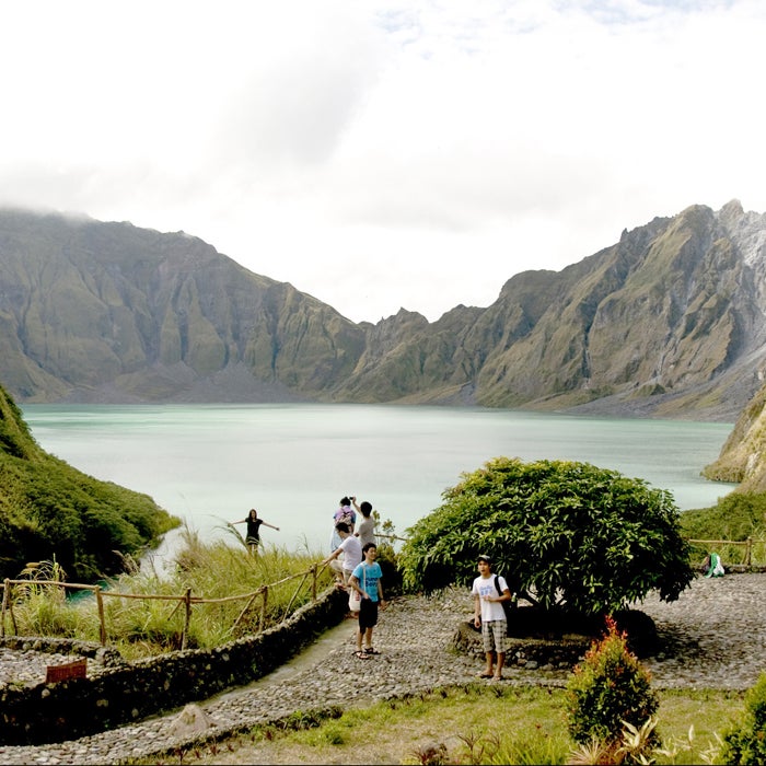
Mount Pinatubo, Philippines
The Pinatubo eruption was the second largest of the century, ejecting at least 15 million tons of sulfur dioxide gas, which lowered temperatures on a global scale, temporarily accelerated depletion of the ozone layer, and brought lahars (showers of volcanic debris) raining down.
If you ignore the volcano’s tendency to blow up suddenly, the hike itself is relatively easy and takes anywhere from 50 minutes to two hours. If you take a dip in the crater lake, beware of floating into the middle, where there are strong currents. (Yabang Pinoy/Flickr)
People come from all over the world to hike up to Mount Pinatubo’s crater lake. But after 400 years of dormancy, this volcano suddenly erupted in 1991, killing 800 people. It erupted again in 1992, that time claiming 72 victims.
The Pinatubo eruption was the second largest of the century, ejecting at least 15 million tons of sulfur dioxide gas, which lowered temperatures on a global scale, temporarily accelerated depletion of the ozone layer, and brought lahars (showers of volcanic debris) raining down.
If you ignore the volcano’s tendency to blow up suddenly, the hike itself is relatively easy and takes anywhere from 50 minutes to two hours. If you take a dip in the crater lake, beware of floating into the middle, where there are strong currents.
Angel's Landing, Utah
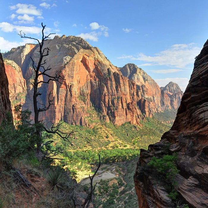
The route, an extension of the West Rim Trail, starts by following a narrow sandstone ridge with steep drop-offs. The final ascent is a steep stone staircase that climbs to the top of a sandstone fin. The path is just wide enough for one person—if someone tries to pass you, you’ll either have to scurry up the rock or step perilously close to the edge. Anchored chains support hikers on the final section. Some people opt out here, letting the more intrepid go on to the exposed platform.
Here’s where things get dangerous. The National Park Service states that at least five people have fallen to their deaths on Angel’s Landing, adding that it’s an incomplete list. That also doesn’t include the people who fall and are rescued, an occurrence that happens almost annually. (tsaiproject/Flickr)
This short hike attracts thousands of people, many of whom take the half-mile trail for granted. Most of the hike is indeed quite tame, but the sheer number of hikers can lead to dangerous traffic jams at the upper point.
The route, an extension of the West Rim Trail, starts by following a narrow sandstone ridge with steep drop-offs. The final ascent is a steep stone staircase that climbs to the top of a sandstone fin. The path is just wide enough for one person—if someone tries to pass you, you’ll either have to scurry up the rock or step perilously close to the edge. Anchored chains support hikers on the final section. Some people opt out here, letting the more intrepid go on to the exposed platform.
Here’s where things get dangerous. The National Park Service states that at least five people have fallen to their deaths on Angel’s Landing, adding that it’s an incomplete list. That also doesn’t include the people who fall and are rescued, an occurrence that happens almost annually.
Bright Angel Trail, Arizona
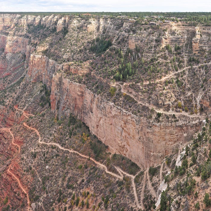
Unlike some Grand Canyon trails, this one has rest stations with water sources along the way. However, many hikers are deceived by how easy this trail is to access, and the descent isn’t too bad, either. They don’t count on the fact that the way out is all uphill and can be oppressively hot as the canyon traps heat—temperatures can be 20 degrees hotter in the canyon than at the rim. Despite warnings posted on the trail in multiple languages, many people make rookie mistakes: They don’t bring enough water, fail to rest enough throughout the hike, or start the hike too late in the day. (Grand Canyon National Park Service/Flickr)
So many people die or are injured on this trail that the park service created a scouting crew dedicated to helping distressed hikers. The 9.5-mile round-trip trail regularly reaches temperatures of 110 degrees, resulting in about 200 heat-related rescues each year.
Unlike some Grand Canyon trails, this one has rest stations with water sources along the way. However, many hikers are deceived by how easy this trail is to access, and the descent isn’t too bad, either. They don’t count on the fact that the way out is all uphill and can be oppressively hot as the canyon traps heat—temperatures can be 20 degrees hotter in the canyon than at the rim. Despite warnings posted on the trail in multiple languages, many people make rookie mistakes: They don’t bring enough water, fail to rest enough throughout the hike, or start the hike too late in the day.
Mount Washington, New Hampshire
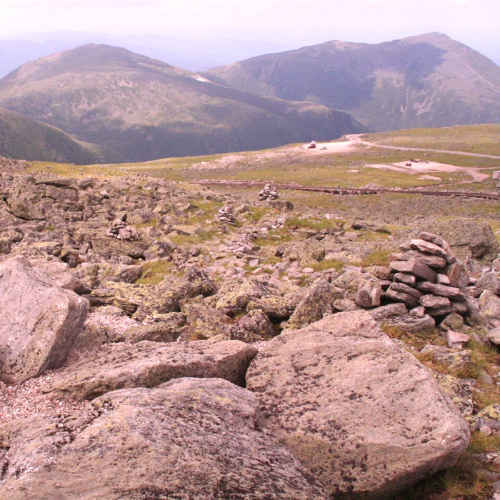
More than a hundred people have died on the mountain, either from being blown off ridges, suffering hypothermia, or being swept away by an avalanche. The average annual temperature is 27.1 degrees, and the summit temperature has never topped 72 degrees. Plus, the mountain holds the world wind-speed record at 231 mph, recorded on the summit in 1934. Expect the ascent to be rocky, steep, and rugged.
“There are no guarantees that hikers will escape the mountain unscathed, so if absolute safety is what you require, then avoid a visit,” says Mount Washington State Park’s website. (Christopher Schmidt/Flickr)
Naive hikers have started their treks here in shorts and T-shirts and suffered hypothermia halfway up when temperatures suddenly plummet. That’s the nature of Mount Washington, a relatively small peak that nonetheless boasts extreme weather. (The Mount Washington Observatory claims to be “Home of the World’s Worst Weather.”)
More than a hundred people have died on the mountain, either from being blown off ridges, suffering hypothermia, or being swept away by an avalanche. The average annual temperature is 27.1 degrees, and the summit temperature has never topped 72 degrees. Plus, the mountain holds the world wind-speed record at 231 mph, recorded on the summit in 1934. Expect the ascent to be rocky, steep, and rugged.
“There are no guarantees that hikers will escape the mountain unscathed, so if absolute safety is what you require, then avoid a visit,” says Mount Washington State Park’s website.
Via Ferrata, Italy and Austria
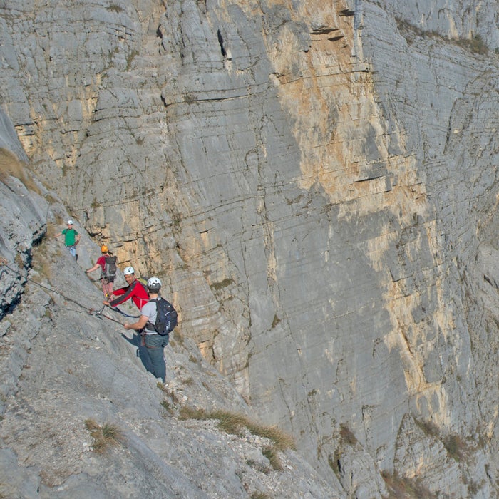
The routes and cables are well maintained, but your safety hinges on snapping a specialized carabiner setup (called a via ferrata set) to the anchors on the cable supports.
Then, you'll scale sheer faces and edge around tall ledges. Deaths have happened on routes of all difficulty levels under a variety of circumstances. In 2009, one British woman plunged to her death on an intermediate hike after slipping on snow and falling 600 feet. Another death in Austria happened because of a gear failure. Watch pro mountain biker Harald Philipp tackle the route on a mountain bike. (Aleksandr Zykov/Flickr)
Europeans in the 15th century once scaled the Via Ferrata (Italian for “iron way”) with ladders, and the route was later used during World War I by specialized troops. Today, routes through the Dolomites are much more accessible thanks to new steel cables, ropes, wooden walkways, and suspension bridges. See the problem?
The routes and cables are well maintained, but your safety hinges on snapping a specialized carabiner setup (called a via ferrata set) to the anchors on the cable supports.
Then, you'll scale sheer faces and edge around tall ledges. Deaths have happened on routes of all difficulty levels under a variety of circumstances. In 2009, one British woman plunged to her death on an intermediate hike after slipping on snow and falling 600 feet. Another death in Austria happened because of a gear failure. Watch pro mountain biker Harald Philipp tackle the route on a mountain bike.
Rover's Run Trail, Alaska
Various signs warn of bear activity, and park authorities close the trail at times when the bruins are out en masse. And they're not the only dangerous animals afoot. Moose, known to charge intruders, are also frequently spotted in the area. (Doug Brown/Flickr)
Rover's Run, a leisurely trail in Anchorage's Far North Bicentennial Park, doesn't have any steep drop-offs, technical climbs, or extreme weather. Instead, it's a favorite spot for brown bears, which flock to the area in the summer when the nearby river is bursting with salmon. There have been so many bear encounters—including maulings—that city and park officials plan to divert the trail away from the creek this year.
Various signs warn of bear activity, and park authorities close the trail at times when the bruins are out en masse. And they're not the only dangerous animals afoot. Moose, known to charge intruders, are also frequently spotted in the area.
Devil's Path, New York
Devil's Path is more than 24 miles long, but the eastern portion has the classic sections, including a six-mile round-trip hike up Indian Mountain. Inexperienced hikers or those with a fear of heights shouldn't venture up this one. It's a steep, unrelenting climb, with sections that require hikers to hoist themselves up by grabbing onto slippery roots. Another spot has a "chimney," where hikers navigate a 10-foot cliff and shimmy around a fallen tree. In many spots, tripping and falling has deadly consequences. You'll also have to contend with moss-covered rocks, deep mud, and water on the path.
According to officials, someone dies almost every year on Devil's Path, whether from a fall or heart attack. (Miguel Vieira/Flickr)
A deadly trail in New York? That’s right, and it's every bit as brutal as the name implies.
Devil's Path is more than 24 miles long, but the eastern portion has the classic sections, including a six-mile round-trip hike up Indian Mountain. Inexperienced hikers or those with a fear of heights shouldn't venture up this one. It's a steep, unrelenting climb, with sections that require hikers to hoist themselves up by grabbing onto slippery roots. Another spot has a “chimney,” where hikers navigate a 10-foot cliff and shimmy around a fallen tree. In many spots, tripping and falling has deadly consequences. You'll also have to contend with moss-covered rocks, deep mud, and water on the path.
According to officials, someone dies almost every year on Devil's Path, whether from a fall or heart attack.
Pacaya Volcano, Guatemala
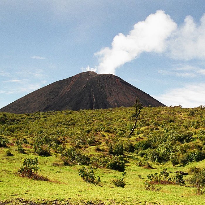
The climb can be dangerous even when the volcano isn't erupting. Hikers have made it to the top of the mountain's steep cinder cone, only to fall in thanks to the hot, crumbling ground.
The national park service closed the 8,000-foot peak to the public after the fatalities, but some stubborn trekkers are still reportedly accessing the volcano from nearby farms.
Active volcanoes typically aren't top tourist attractions, but Guatemala's Pacaya, located near the capital city, is different. Pacaya became active again in 1965. Since then, eruptions have killed a handful of people.
The climb can be dangerous even when the volcano isn't erupting. Hikers have made it to the top of the mountain's steep cinder cone, only to fall in thanks to the hot, crumbling ground.
The national park service closed the 8,000-foot peak to the public after the fatalities, but some stubborn trekkers are still reportedly accessing the volcano from nearby farms.