
Snow slid into the valley on Thursday morning, marking a return to wintry conditions after flowers began to bloom in some areas.

With a few centimetres expected to fall during the day, with temperatures flirting with the freezing mark, the snow will start to slow into the evening, with clouds lingering overnight.
The second full week of 2019 will wrap up with another wave of clouds sweeping through, with a Friday afternoon high hoping to make it a few degrees above freezing.
The next round of snow is slated for Friday night as a frontal boundary sweeps through the region.

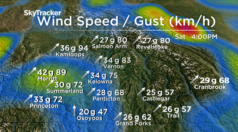
The result will be a warm kickoff to the weekend, with the mercury bouncing back up into mid-single digits with a breezy southwesterly wind kicking in, pumping out 70 km/h gusts at times.
Slightly cooler conditions swing in on Sunday, but they will come with some vitamin D generating sunshine, with temperatures climbing up to around 4 degrees for an afternoon high.


The work week ahead will begin with some sun as well, which will bring in some cool morning lows and daytime highs staying a few degrees above freezing.
Clouds will be back by mid-week, carrying with them some more precipitation and afternoon highs staying above the seasonal average.

For weather on the go download the Global News SkyTracker Weather App for iPhone, iPad or Android.
- Budget 2024 failed to spark ‘political reboot’ for Liberals, polling suggests
- Train goes up in flames while rolling through London, Ont. Here’s what we know
- Peel police chief met Sri Lankan officer a court says ‘participated’ in torture
- Wrong remains sent to ‘exhausted’ Canadian family after death on Cuba vacation
Comments