The solid Earth changes very slowly, generally speaking—so slowly that short-lived and fast-changing creatures like ourselves can be forgiven for forgetting that it changes at all. It's hard to imagine the land we live on sitting beneath three kilometers of glacial ice or sitting under open ocean; it's like imagining a painting of a different place.
This is partly what makes volcanic islands so wild. When they erupt, the island changes quickly and obviously. And if you’re extremely lucky, you might even catch the birth of a new island. A place that had long been sea becomes land, and you can watch it happen—no CGI or imagination required. And we now have robotic eyes constantly scanning the globe from space, so we no longer rely on the luck of being in the right place at the right time to observe such an event.
In the Red Sea between Africa and the Arabian Peninsula, there is a small chain of islands, called the Zubair Archipelago, with an interesting history. Just as Africa is slowly splitting apart along the volcanically active East African Rift, the Arabian Peninsula is breaking up with Africa along the Red Sea. In the 1700s and 1800s, the Zubair Archipelago hosted eruptions—the only recorded in the Red Sea—but they went quiet through the 20th century. In 2007, they woke up, with an eruption popping on one of the islands.
In 2011 and 2013, there were more eruptions, but this time they came from the seafloor and resulted in new islands. King Abdullah University of Science and Technology researchers Wenbin Xu, Joël Ruch, and Sigurjón Jónsson took advantage of satellite imagery and surface elevation measurements to observe their births.
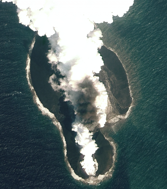
The first eruption, at what is now called Sholan Island, was spotted by fishermen in mid-December 2011 and continued for nearly a month. It started as a long fissure, but soon narrowed to a single vent coughing up ash and chunks of rock as it broke through the surface of the water. When it was done, the island reached almost a hundred meters above the surface, with an area of a quarter square kilometer.
But the show didn’t end there. Some Yemeni scientists who visited the newborn island a few days later could see small landslides still moving rock around, and wind and wave reshaped the island over the next couple of months. The island’s shape even changed with the seasons after that, as seasonal cycles in the prevailing winds shifted a skirt of loose material to the northern or southern sides of the island. The crater in the center of the island even filled with seawater as it seeped through the permeable rock.
An ash cloud returned in late September 2013, just eight kilometers away from Sholan. This eruption lasted for almost two months and built a larger island called Jadid with a peak 186 meters above the surface and an area of about 0.7 square kilometers. The erosion of this island wasn’t as striking, but it also shrank very slightly over time.
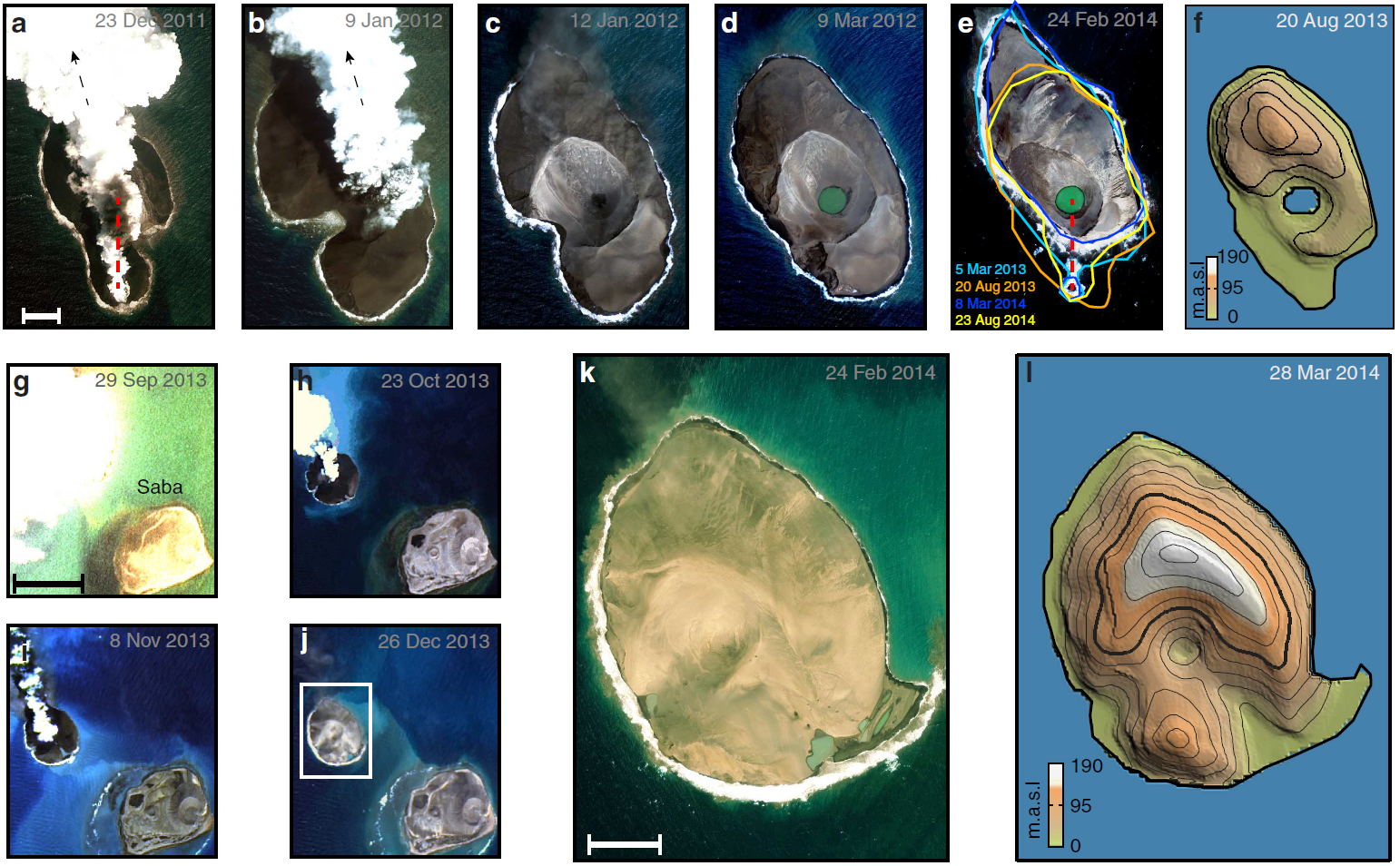
Using sensitive satellites that can detect subtle changes in surface elevations (a few centimeters or less) on the other islands, the researchers were also able to learn about things they couldn’t see in the photos. Faults, open fractures, and small motions on nearby islands showed what the magma had been doing below the surface of the eruptions. Long vertical sheets of magma called dikes, pointing roughly north-south and about ten kilometers long, had inflated and then escaped through the volcanoes.
It’s a little puzzling that these dikes weren’t quite parallel to the overall orientation of the Red Sea, but this is the kind of thing we see in rift zones. This rift zone may be pretty quiet, volcanically, but GPS measurements tell us the southern part of the Red Sea gets about six millimeters wider each year. And while there was a noticeable uptick in earthquakes preceding these eruptions, there has been consistent earthquake activity in that area for decades—an indication that magma has been busy moving around below the surface.
Because of all this, the researchers call the Zubair Archipelago “the surface expression of an active spreading segment that was previously under appreciated.” And that means we can expect that Sholan and Jadid islands are unlikely to be the last additions to the family.
Open Access at Nature Communications, 2015. DOI: 10.1038/ncomms8104 (About DOIs).
reader comments
20